

The territory of Roissy Pays de France Focus more than 350,000 inhabitants and 180,000 jobs, a significant part of which is linked to airport and logistics activities.
This dynamism generates very structuring home-work flows, often long and dependent on the car.
In this context, CARPF wanted to build a Local Mobility Plan to guide its public policies and support future changes.
Explain led the approach by involving all the institutional and economic actors of the territory: companies in the airport cluster, transport operators, municipalities and users.
The mission was structured around four main components:
Explain made sure to link the PLM with existing planning documents (SCoT, PCAET, Ecological Transition Contract) to ensure overall coherence at the scale of the Roissy employment area.
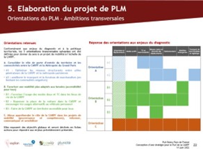
The mission aimed to provide CARPF with a strategic and unifying tool to plan mobility in a particular economic context.
The main objectives were to:
The Roissy Pays de France Local Mobility Plan Constitutes a interinstitutional coordination model, in the service of inclusive, efficient mobility adapted to an international employment area.
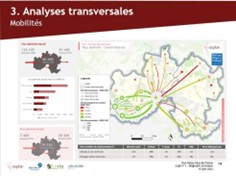
Explain provides an overall prospective vision in terms of mobility strategy and at the same time operational. This is reflected in learning about mobility issues as close as possible to the realities of the territory as well as in putting regional mobility issues into perspective. This need is all the more exacerbated by the health crisis and the major, rapidly evolving, logistical problems in the territory of Roissy Pays de France.


%20(1).webp)