

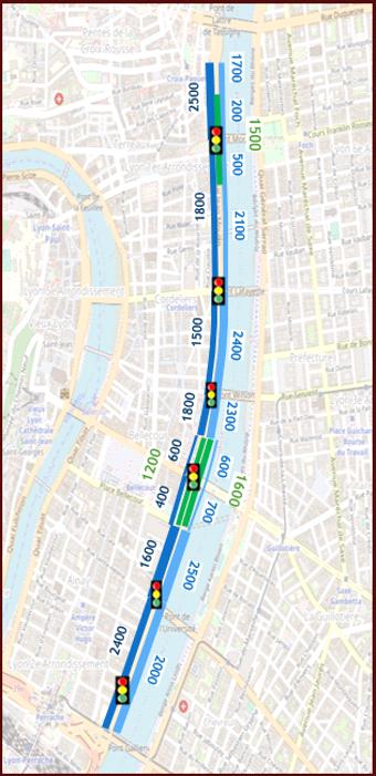
La Right bank of the Rhône, located on the eastern part of the center of Lyon, is a strategic metropolitan traffic corridor, supporting both transit traffic and local services and uses linked to major urban areas on the banks of the river (Gerland, Perrache, Part-Dieu).
In a context of gradual requalification of shorelines and the rise of sustainable mobility policies, Metropolis of Lyon Mandated Explain To establish a detailed diagnosis of the operation of the axis and provide a technical basis for future planning decisions.
The study was based on:
The work made it possible to Precisely locate saturation points, to assess the effects of congestion on load shedding routes and to propose short and medium term optimization opportunities (adjustment of road signs, redefinition of the hierarchy of axes, reinforcement of cycle routes).
The objective of this mission was to provide the Metropolis with a global and objective vision of the functioning of the Right Bank of the Rhône, in the perspective of requalification projects with a high urban challenge.
Explain was supposed to:
The study allowed the Métropole de Lyon to have a complete and quantified inventory, integrating the diversity of uses and traffic temporalities. The analyses carried out facilitated the coordination between the departments of roads, mobility and urban planning, by providing a shared basis for understanding the issues at stake. Explain has thus contributed to guide metropolitan thinking towards better integration between traffic and development, by reconciling network performance and urban quality on the banks of the Rhône.
The study of the Right Bank of the Rhône constitutes a decision support tool for the Lyon Metropolis, making it possible to support the requalification of this emblematic axis in a perspective of sustainable mobility and urban reconquest.


%20(1).webp)