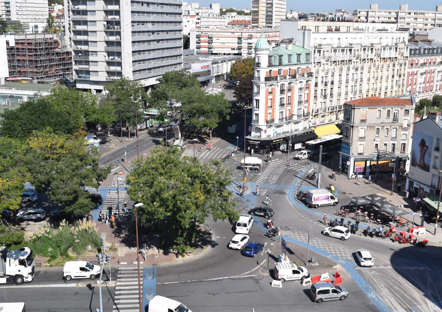
Redevelopment of the Croix de Chavaux — City of Montreuil

Explain supported the City of Montreuil and EPT Est Ensemble in the redevelopment of Place de la Croix de Chavaux, an emblematic space in the city center. The traffic study aimed to objectify the current operating conditions, to anticipate the effects of the planned developments and to ensure the compatibility between appeasement, accessibility and network performance.

Revision of the Mobility Plan — SIMOUV (Valenciennois)

SIMOUV, the organizing authority for mobility in Valenciennes, has entrusted Explain with the development of its Mobility Plan (PDM), a framework document setting out the guidelines for the development of mobility by 2035. The approach made it possible to establish a shared territorial vision, reconciling economic attractiveness, sustainable mobility and equitable access, in a region marked by industrial reconversion and strong dependence on the car.

Mobility and urban planning — SCoT and Plui-HD — Agglomération d'Agen

Explain supported the Communauté d'Agglomération d'Agen in defining the mobility strategy integrated with the revision of its SCoT and in the development of the Plui-HD. The mission made it possible to translate development guidelines into concrete objectives of service, accessibility and sustainable mobility, by ensuring coherence between urban planning, mobility and the environment.

Local Mobility Plan — Roissy Pays de France

The Communauté d'Agglomération Roissy Pays de France (CARPF) has entrusted Explain with the development of its Local Mobility Plan (PLM), covering a strategic territory in the north of Île-de-France, marked by the presence of the Paris-Charles de Gaulle airport hub. The mission made it possible to coordinate mobility, employment and development policies around a shared vision, reconciling economic attractiveness and ecological transition.

Socio-economic evaluation of the Réseau Express Métropolitain — Rouen Métropole/SNCF Réseau

Socio-economic evaluation of the Réseau Express Métropolitain project in Rouen. Scenarios, time savings, costs, balance sheets, structuring effects.

Multimodal model Modély — Métropole de Lyon

Development and exploitation of the Modély multimodal model, a strategic simulation tool for the Lyon metropolitan area.

Study of flows and parking at Provins station

Explain supported the Communauté de Communes du Provinois in carrying out a study of drawdown and uses around Provins station, with a view to the requalification of former SNCF buildings and land. The study made it possible to identify the profiles and behaviors of users, to distinguish between drawdown uses and those of residents, and to propose programmatic guidelines adapted to the needs of the territory.

Esbly multimodal interchange hub

Complete study of the Esbly station hub aimed at requalifying mobility areas, strengthening intermodality and anticipating the arrival of the TCSP EVE, the future structuring axis of Val d'Europe Agglomération.

Modernizing the Bison Futé forecasting model

Explain modernized Bison Futé's historical traffic forecasting model by integrating machine learning methods. This evolution makes it possible to improve the accuracy of forecasts, to strengthen the robustness of the model and to pave the way for a more flexible approach, capable of integrating new contextual data.

Socio-economic modeling and evaluation study of the Nancy—Belfort service

Explain carried out for the DGITM a modeling and socio-economic evaluation study of the Nancy—Belfort service, integrated into the Épinal—Belfort line regeneration project. The objective: to measure time savings, traffic trends and the economic effects of an optimized direct service, connected to the TGV in Belfort-Montbeliard.

Multimodal model of the European Metropolis of Lille

Explain has developed a multimodal travel model for the European Metropolis of Lille (MEL), integrating road and public transport flows throughout the Lille district. This decision support tool makes it possible to test the effects of Transport Infrastructure Master Plan (SDIT) projects and to assess the socio-economic impacts of mobility policies in the short and medium term.

Combined transport model

Explain has built a combined transport model at the national and European levels to simulate freight flows and estimate the potential for modal shift to rail and waterways. The study is based on the constitution of 2019 reference matrices, describing interregional and international freight exchanges by mode, in order to feed public policies and logistics investment strategies.

MODEOS model update

Explain has updated the MODEOS model, a multimodal simulation tool covering the territory of Métropole Savoie, the Savoyard Avant-Pays and the Bauges. This redesign integrates the most recent data from the EMC² 2022 survey, a complete reconstruction of travel behavior, and a detailed review of observed road, bicycle and public transport traffic.

Dynamic congestion modeling

Explain has developed a dynamic traffic model for DIR Méditerranée on the A50/A501 corridor between Aubagne and Marseille, in order to assess the effectiveness of a fire control system intended to reduce congestion and improve the regularity of public transport. The study is based on a dynamic macroscopic model such as LWR (Lighthill—Whitham—Richards), making it possible to finely simulate the phenomena of queue and propagation of congestion.

Operational study - Round Ash Sector

Explain supported Nantes Métropole in a study of the functioning of the Round Ash sector, in Saint-Sébastien-sur-Loire. This mission complements the reflections carried out around the peaceful city and the generalized transition to 30 km/h, by evaluating the impact of urban projects on traffic and parking.

Traffic study on Place Léon Blum (EPT Grand Paris Seine Ouest)

Explain supported Grand Paris Seine Ouest in the traffic study related to the redevelopment of Place Léon Blum in Issy-les-Moulineaux. The objective: to model the impacts of the extension of bus line 39 and to propose optimal integration solutions reconciling general traffic, accessibility and the performance of public transport.

Bruniquel, Montricoux and Cazals mobility study (ANCT)

Explain supported the municipalities of Bruniquel, Montricoux and Cazals, as part of the Villages d'Avenir program led by the ANCT, to develop a concerted traffic plan adapted to the specificities of these heritage and tourist villages. The approach made it possible to co-build with elected officials and residents traffic scenarios that balance accessibility, appeasement and enhancement of the living environment.

Traffic study - Le Pellerin

Explain supported Nantes Métropole in the analysis of the traffic plan for the center of Pellerin, in addition to an existing urban study. The study aimed to assess the coherence between the summary scenario and the real traffic, parking and service conditions, by identifying the adjustments necessary to reconcile fluidity, security and peace of mind.

Traffic study at the right of the level crossing

Explain supported the Métropole de Lyon and SNCF Réseau in analyzing the operation of level crossing No. 310 in Collonges-au-Mont-d'Or, the only railway crossing point accessible to heavy vehicles and active modes. The study made it possible to precisely characterize current flows and to propose ways of optimization to improve the safety and continuity of travel.

Temporal one-way

Explain supported Nantes Métropole in the study of the opportunity to make the bridges of Thouaré and Saint-Julien-de-Concelles in a one-way temporal way, in order to free up space for active modes and secure the crossing of the Loire. The study combined benchmark, modeling and multi-criteria analysis to assess the impacts of several operating configurations.

Mobility study — Cordes-sur-Ciel

Explain supported the city of Cordes-sur-Ciel and the ANCT in developing a traffic plan adapted to the historic center of the medieval city. The study made it possible to analyze the current mobility conditions, to identify the challenges of sharing public space and to co-construct an operational planning scenario with local actors.

Displacement study — Saint-Médard-en-Jalles

Explain supported Bordeaux Métropole in developing the travel plan for the municipality of Saint-Médard-en-Jalles, by integrating recent projects and the political orientations of the community. The study made it possible to define a hierarchical and realistic traffic plan, based on the simulation and evaluation of various development scenarios.

Traffic study on the Right Bank of the Rhône

Explain supported the Lyon Metropolis in analyzing the functioning of traffic on the Right Bank of the Rhône, between Guillotière and Mulatière. The study aimed to objectify current traffic conditions, to identify major dysfunctions and to assess the potential effects of current development projects on this structural axis.

Camera-based road count campaign — La Défense

Explain supported the Interdepartmental Public Establishment 78/92 in a vast campaign of road counts on the circular boulevard of La Défense, in preparation for the Paris 2024 Olympic Games. The operation mobilized camera vision solutions and machine learning algorithms to process more than 10,000 hours of videos, offering a detailed analysis of flows in one of the densest sectors in Europe.

Multimodal drawdown surveys

Explain supported SYTRAL Mobilities in carrying out a multimodal drawdown and dissemination survey around Villefranche-sur-Saône and Anse stations, in addition to the studies already carried out on the rest of the Villefranche—Lyon axis. The mission aimed to characterize the travel practices of users, their access methods and their uses of car parks, in order to guide the territory's mobility policies.

Solution for counting and monitoring attendance at the Lugdunum site and museum

Explain, in partnership with Kiomda, has deployed a complete solution for counting and monitoring attendance at the Lugdunum Museum and Archaeological Park in Lyon. The device, combining autonomous thermal sensors and continuous data analysis, allows long-term monitoring of site attendance, guaranteeing the reliability, robustness and discretion necessary for a sensitive heritage environment.

Bicycle counters at the entrances of the Hôpitaux Est de Lyon

Explain supported the Hospices Civils de Lyon (HCL) in carrying out a campaign to count bicycle flows near the Hôpitaux Est — Bron, in order to better understand cycling uses on the site and to assess the cohabitation between bicycles, pedestrians and vehicles. The data collected continuously for one week made it possible to quantify real attendance and to identify the needs for facilities and security.

Revision of the Mobility Plan — Grand Besançon Métropole

Explain supported Grand Besançon Métropole in the complete revision of its Mobility Plan (PDM), a strategic reference document for the organization of travel throughout the agglomeration. The mission made it possible to define a new strategy for shared and carbon-free mobility, built around a broad consultation process, a prospective analysis of needs and a fine integration with other territorial policies.

Definition of a major pedestrian network

Explain supported the Métropole de Lyon in defining the first metropolitan pedestrian master network, a strategic tool aimed at positioning walking as a structuring mode of travel in the same way as cycling or public transport. The mission made it possible to map, prioritize and qualify pedestrian continuities at the metropolitan level, by integrating the challenges of accessibility, networking and territorial coherence.

Regional master plan for carpooling areas

Explain supported the Occitanie Region in the development of its regional master plan for carpooling areas, covering the entire regional territory. The study made it possible to characterize the existing supply, potential demand and development needs, in order to define a coherent, prioritized deployment strategy adapted to the challenges of each mobility basin.

Simplified mobility plans and cycling master plans — Pôle Métropolitain du Grand Amiénois

The Grand Amiénois Metropolitan Area has entrusted Explain with the development of simplified mobility plans (PDMs) and cycling master plans for its six member intermunicipalities. This collective and unprecedented approach at the territorial level has made it possible to structure the mobility policy of Grand Amiénois, to identify investment priorities and to coordinate cycling and intermodal actions in a logic of regional coherence.

Multimodal vision 2030 for the transport corridors of the Métropole de Lyon

The Lyon Metropolis has entrusted Explain with the creation of a multimodal vision by 2030, aimed at prioritizing and structuring the territory's transport corridors. This strategic study, at the crossroads of planning and forecasting, made it possible to rethink the distribution of mobility functions on major axes, in a logic of coherence between urban planning, travel and climate transition.

Regional cycling strategy — Normandy Region

The Normandy Region commissioned Explain to develop its regional cycling strategy, a genuine reference framework for public action in favor of cycling. The study made it possible to define a unified vision of the development of cycling at the regional level, reconciling tourist attractiveness, daily mobility and energy transition goals.

Socioeconomic evaluation of the Grand Sud-Ouest Project (GPSO) — SNCF Réseau

SNCF Réseau has entrusted Explain with the socio-economic evaluation of the Grand Projet du Sud-Ouest (GPSO), including the new Bordeaux—Toulouse and Bordeaux—Dax lines. The study made it possible to quantify the economic, environmental and territorial impacts of one of the largest French rail projects, while testing several scenarios for implementation and operation by 2050.

Socio-economic evaluation of the extension of the Bobigny Judicial Court

The Ministry of Justice commissioned Explain to carry out the socio-economic evaluation of the project to extend the Bobigny Judicial Court, the second largest jurisdiction in France after Paris. The study made it possible to quantify the economic, social and territorial impacts of the project, by demonstrating its contribution to the improvement of the functioning of the public justice service and to the urban requalification of the district.

Opportunity study for routes on the RN147 between Limoges and Poitiers

DREAL Nouvelle-Aquitaine has commissioned Explain to carry out a study of the opportunity of routes on the RN147 between Limoges and Poitiers, as part of the reflection on improving the link between these two regional capitals. The study aimed to assess possible development scenarios (optimization of the existing road or the creation of new sections) in terms of their technical, economic and environmental performances.

LOTI report on the A89—A6 link

The APRR dealer commissioned Explain to carry out the LOTI assessment of the A89—A6 motorway link, connecting Aquitaine to the Rhone furrow. The study aimed at evaluating the real effects of the project on mobility, safety, the environment and territorial development a posteriori, in accordance with the requirements of the LOTI law (Inland Transport Orientation Law).

Implementation of the Metropolitan Low Emission Zone (ZFE+) of Greater Lyon

The Métropole de Lyon has entrusted Explain with the socio-economic assessment prior to the implementation of the Low Emission Zone (ZFE+), a device intended to reduce air pollution and accelerate the energy transition of the metropolitan vehicle fleet. The study made it possible to objectify the economic, environmental and social impacts of the system, in order to inform the choices of scope, schedule and support for households and businesses.

All-mode traffic study — Nantes city center

Nantes Métropole commissioned Explain to carry out a study of all-mode traffic in downtown Nantes, as part of a global project to requalify and calm public space. The study aimed to analyze travel flows, to assess the impact of new developments and to propose balanced traffic scenarios reconciling urban attractiveness, accessibility and ecological transition.

Reestimation of time values and determinants of road route choice — DGITM

The Directorate-General for Infrastructures, Transport and the Sea (DGITM) has entrusted Explain with the re-estimation of time values and the determinants of road route choice at the national level. This major methodological exercise aims to update the behavioral reference parameters used in French transport models, in order to better represent contemporary mobility practices and changes in the road network.

Assessing the effects of MaaS on mobility practices — Île-de-France Mobilities

Île-de-France Mobilities (IDFM) has entrusted Explain with a pioneering study on the impact of MaaS (Mobility as a Service) on daily travel practices. The objective: to quantify, model and anticipate the effects of new subscription scenarios and the integration of mobility services, in order to assess their potential in terms of modal shift and optimization of uses.

Creation of the multimodal model of the Rouen Metropolis

The Rouen Normandy Metropolis has entrusted Explain with the creation of a multimodal travel model, intended to become the central simulation and decision-making tool for all metropolitan mobility policies. The model, designed as an integrated knowledge and forecasting platform, makes it possible to assess the impacts of infrastructure projects, changes in transport supply or pricing policies, in the short and long term.

Development strategy for the Rouen railway station

The study aims to analyze the current and future performance of the Rouen rail network, to quantify the effects of modernization projects and to build a strategic vision for development by 2040.

Prospective study 2040 for the Toulouse agglomeration

Tisséo Collectivities has commissioned Explain to carry out a prospective study by 2040, based on the multimodal model of the Toulouse metropolitan area. The objective: to anticipate the joint effects of urban growth, energy transition and new transport projects on travel flows, in order to inform long-term planning and investment choices.

Audit of the traffic forecasting model for the Paris 2024 Olympic and Paralympic Games

Île-de-France Mobilities (IDFM) commissioned Explain to carry out the complete audit of the traffic forecasting model developed for the Paris 2024 Olympic and Paralympic Games. The objective of the mission: to guarantee the reliability, coherence and transparency of the simulation tool used to anticipate the exceptional flows generated by the event and plan multimodal service to the Île-de-France region.

Mobility and parking expertise from PUP Grand Plantier

As part of the “Grand Plantier” urban project in Saint-Romain-au-Mont-d'Or, led by Nexity and the Lyon Metropolitan Area, Explain carried out a mobility and parking expertise to anticipate the needs generated by the new district and adapt the traffic plan to the challenges of the site.

Mobility expertise — ZAC des Alagniers in Rillieux-la-Pape

As part of the urban renewal project of the ZAC des Alagniers, which is part of the ANRU national program, Explain is supporting the Lyon Metropolis on the management of mobility and the analysis of multimodal flows linked to the transformation of the district.

Improving and securing active mode traffic — Hôpital Lyon Sud

In a context of restructuring the Lyon Sud hospital site, Explain is supporting the Hospices Civils de Lyon in the development of a global traffic and soft mobility plan. The study aims to improve the safety and legibility of pedestrian and bicycle paths, while preparing for consistency with future urban developments in the sector.

Bicycle parking study — Collège Jean Vilar

The Department of Yvelines asked Explain for a bicycle parking study at Jean Vilar des Mureaux middle school, in order to size a future bicycle shed and to support the CD78 cycling policy.

ESE — Railway modernization in Bercy

In a context of high demand on the Paris — Gare de Lyon/Bercy railway complex, SNCF Réseau — Direction Générale Île-de-France entrusted Explain with carrying out the economic and social assessment (ESE) of an infrastructure modernization project (ESE) of an infrastructure modernization project. The mission aims to objectify the socio-economic benefits of several intervention scenarios, in the perspective of the public inquiry prior to the project.

Study on the consideration of agglomeration effects in the socio-economic evaluation of SERMs

The DGITM has commissioned Explain with a methodological study aimed at integrating agglomeration effects into the socio-economic evaluation of Metropolitan Regional Express Services (SERM). The objective of the mission is to formalize a robust and operational valuation method, making it possible to take into account, beyond time savings and traditional externalities, the economic and urban impacts induced by improving accessibility.

New EuroAirport rail link — Socio-economic assessment

SNCF Réseau has commissioned Explain to carry out the socio-economic assessment of a project for a direct rail link to EuroAirport Basel-Mulhouse—Freiburg. The study aims to objectify the impacts of a Franco-Swiss regional rail service, in support of the definition of a planning party and the preparation of the public inquiry.

Inter-company mobility plan (PDIE) — Business areas in Oise

The SMTCO — Syndicat Mixte des Transports Collectives de l'Oise, as an Organizing Authority for Mobility, has entrusted Explain with the support for the deployment of Inter-Company Travel Plans (PDIE) in several business areas in the territory. The mission aims to structure mobility approaches adapted to local realities, promoting the modal shift towards public transport, active modes and shared uses of the car.

Bicycle integration of the Cardiff—Aiguillon—Renaud quays

As part of the Nantes Métropole Bicycle Routes Master Plan, Explain is supporting the local authority on the cycling integration study of the Cardiff—Aiguillon—Renaud quays. The mission aims to define development guidelines for the creation of a major cycle path with a high level of service, by integrating all road uses: general traffic, buses, pedestrians and vegetation.

Study on the restructuring of the bus network in connection with the extension of metro B

As part of the extension of metro B from the Lyon metropolitan area to the Oullins Centre and Hôpitaux Sud stations, Sytral Mobilities has entrusted Explain with a study to restructure the surface network. The objective of the mission is to adapt the bus offer of the TCL and Cars du Rhône networks in order to take full advantage of the new infrastructure and to respond to changes in travel practices in the territory concerned.

Support in responding to tenders for the operation of the Niort network

As part of the competition for the operation of the public transport network in the agglomeration of Niort, Transdev asked Explain to assist it with traffic forecasts and the analysis of the future needs of the network. The mission aims to secure traffic hypotheses and to support the construction of an adapted offer in a context of free transport and population growth.

Pole study — Val d'Europe Montévrain train station

The Communauté d'Agglomération de Marne et Gondoire has commissioned Explain to carry out the pole study for Val d'Europe Montévrain station, in a context of strong urban and economic development in the Marne-la-Vallée sector. The mission aims to build a prospective and sustainable vision of the developments around the station, in close coordination with urban studies conducted on the planned development areas.

Assessing the effects of MaaS on mobility practices — Île-de-France Mobilities

Île-de-France Mobilities (IDFM) has entrusted Explain with a pioneering study on the impact of MaaS (Mobility as a Service) on daily travel practices. The objective: to quantify, model and anticipate the effects of new subscription scenarios and the integration of mobility services, in order to assess their potential in terms of modal shift and optimization of uses.

Bicycle counters at the entrances of the Hôpitaux Est de Lyon

Explain supported the Hospices Civils de Lyon (HCL) in carrying out a campaign to count bicycle flows near the Hôpitaux Est — Bron, in order to better understand cycling uses on the site and to assess the cohabitation between bicycles, pedestrians and vehicles. The data collected continuously for one week made it possible to quantify real attendance and to identify the needs for facilities and security.

Solution for counting and monitoring attendance at the Lugdunum site and museum

Explain, in partnership with Kiomda, has deployed a complete solution for counting and monitoring attendance at the Lugdunum Museum and Archaeological Park in Lyon. The device, combining autonomous thermal sensors and continuous data analysis, allows long-term monitoring of site attendance, guaranteeing the reliability, robustness and discretion necessary for a sensitive heritage environment.

Multimodal drawdown surveys

Explain supported SYTRAL Mobilities in carrying out a multimodal drawdown and dissemination survey around Villefranche-sur-Saône and Anse stations, in addition to the studies already carried out on the rest of the Villefranche—Lyon axis. The mission aimed to characterize the travel practices of users, their access methods and their uses of car parks, in order to guide the territory's mobility policies.

Audit of the traffic forecasting model for the Paris 2024 Olympic and Paralympic Games

Île-de-France Mobilities (IDFM) commissioned Explain to carry out the complete audit of the traffic forecasting model developed for the Paris 2024 Olympic and Paralympic Games. The objective of the mission: to guarantee the reliability, coherence and transparency of the simulation tool used to anticipate the exceptional flows generated by the event and plan multimodal service to the Île-de-France region.

Development strategy for the Rouen railway station

The study aims to analyze the current and future performance of the Rouen rail network, to quantify the effects of modernization projects and to build a strategic vision for development by 2040.

Creation of the multimodal model of the Rouen Metropolis

The Rouen Normandy Metropolis has entrusted Explain with the creation of a multimodal travel model, intended to become the central simulation and decision-making tool for all metropolitan mobility policies. The model, designed as an integrated knowledge and forecasting platform, makes it possible to assess the impacts of infrastructure projects, changes in transport supply or pricing policies, in the short and long term.

Regional cycling strategy — Normandy Region

The Normandy Region commissioned Explain to develop its regional cycling strategy, a genuine reference framework for public action in favor of cycling. The study made it possible to define a unified vision of the development of cycling at the regional level, reconciling tourist attractiveness, daily mobility and energy transition goals.

Esbly multimodal interchange hub

Complete study of the Esbly station hub aimed at requalifying mobility areas, strengthening intermodality and anticipating the arrival of the TCSP EVE, the future structuring axis of Val d'Europe Agglomération.

Study of flows and parking at Provins station

Explain supported the Communauté de Communes du Provinois in carrying out a study of drawdown and uses around Provins station, with a view to the requalification of former SNCF buildings and land. The study made it possible to identify the profiles and behaviors of users, to distinguish between drawdown uses and those of residents, and to propose programmatic guidelines adapted to the needs of the territory.

Multimodal model Modély — Métropole de Lyon

Development and exploitation of the Modély multimodal model, a strategic simulation tool for the Lyon metropolitan area.

Socio-economic evaluation of the Réseau Express Métropolitain — Rouen Métropole/SNCF Réseau

Socio-economic evaluation of the Réseau Express Métropolitain project in Rouen. Scenarios, time savings, costs, balance sheets, structuring effects.

Bicycle integration of the Cardiff—Aiguillon—Renaud quays

As part of the Nantes Métropole Bicycle Routes Master Plan, Explain is supporting the local authority on the cycling integration study of the Cardiff—Aiguillon—Renaud quays. The mission aims to define development guidelines for the creation of a major cycle path with a high level of service, by integrating all road uses: general traffic, buses, pedestrians and vegetation.

Inter-company mobility plan (PDIE) — Business areas in Oise

The SMTCO — Syndicat Mixte des Transports Collectives de l'Oise, as an Organizing Authority for Mobility, has entrusted Explain with the support for the deployment of Inter-Company Travel Plans (PDIE) in several business areas in the territory. The mission aims to structure mobility approaches adapted to local realities, promoting the modal shift towards public transport, active modes and shared uses of the car.

New EuroAirport rail link — Socio-economic assessment

SNCF Réseau has commissioned Explain to carry out the socio-economic assessment of a project for a direct rail link to EuroAirport Basel-Mulhouse—Freiburg. The study aims to objectify the impacts of a Franco-Swiss regional rail service, in support of the definition of a planning party and the preparation of the public inquiry.

Study on the consideration of agglomeration effects in the socio-economic evaluation of SERMs

The DGITM has commissioned Explain with a methodological study aimed at integrating agglomeration effects into the socio-economic evaluation of Metropolitan Regional Express Services (SERM). The objective of the mission is to formalize a robust and operational valuation method, making it possible to take into account, beyond time savings and traditional externalities, the economic and urban impacts induced by improving accessibility.

Join a team expert and committed

Explain is a demanding, caring team, and always curious to welcome new profiles. Do you want to learn, transmit and have a real impact on the mobility of tomorrow? Let's talk about it.

Text Rotate
Background Image